
February 25, 2022
Jeremy Bennington

BVLOS drone flight is getting closer, one waiver at a time. Since 2018, the Federal Aviation Authority has waived its CFR Part 107.31 rules 72 times, authorizing operators of small unmanned aerial systems (sUAS) to fly beyond the visual line of sight (BVLOS) of the remote pilot in command (RPIC) of the drone or a designated visual observer (VO). For UAS weighing over 55 pounds, the FAA also offers Part 91 and 61 exemptions.
Among the Part 107 waiver recipients to date are Alphabet’s Project Wing, which is trialing drone package delivery, Matternet, which is trialing drone delivery of medical samples, and ARE, which offers drone-based inspection for utility lines. These are all promising UAS use cases, and the FAA is committed to enabling the “virtually limitless benefits” that operations like these can provide.
But the challenge facing the FAA (and its counterparts around the world) is to ensure drones can operate BVLOS without creating safety risks – either for other airspace users, or for people and structures on the ground. This huge task involves rethinking how airspace is segregated, how air traffic is managed when it includes millions of unmanned vehicles as well as traditional aircraft, and how drone safety and airworthiness are assessed and demonstrated.
That process is ongoing with the FAA BVLOS Aviation Rulemaking Committee (ARC) which will lead to formal regulation in the years to come. In the meantime, any company wanting to fly BVLOS must apply for a CFR Part 107.31 waiver or Part 61/91 exemption. To obtain one, they must demonstrate that their UAS can operate safely.
For Part 107 waivers, this starts with the FAA Order 8040.6 “Unmanned Aircraft Systems Safety Risk Management Policy.” A key requirement of this order relates to GPS reliability. Every Part 107 waiver we’ve seen (they are all published on the FAA website) specifies that the drone must have a reliable GPS signal throughout its flight.
Part 107 waivers granted to Wing, Matternet and ARE, for example, all include the following requirement: “Operations subject to this waiver must cease if, at any time: GPS signal is lost, or GPS location information is degraded.”
For Part 61/91 exemptions relating to larger and heavier drones, the FAA states that the flight must not even start if GPS reliability is not assured for the flight. The exemption issued to A-Cam Aerials, for example, states that: “The PIC may not begin or continue a flight if any global positioning system (GPS) outage, signal fault, integrity issue, Notice to Airmen in effect for any part of the planned operational area, or any other condition that affects or could affect the functionality or validity of the GPS signal.”
To highlight a related consideration of GPS reliability and performance, the waiver went on to state: “Geo fencing relies on GPS accuracy. For this software to be effective as a mitigation, the PIC must know the GPS location certitude of its UAS system and factor that in to his or her planning. For example, if the GPS location certitude of the UAS is +/- 10 feet, then add 10 feet to the buffers between the UAS and filming personnel.”
These requirements point to a regulatory future where navigation will form a crucial part of any defined regulations. That may not be so much of an issue for operations in open rural spaces. But for services designed to operate in urban or suburban areas, it could be a deal-breaker.
That’s because the drone needs radio line of sight to at least four satellites (or six, if it’s also using an augmentation service like WAAS or SBAS) to accurately calculate its position. If line of sight to those satellites is blocked or distorted by trees or buildings, even for a few seconds, the drone’s GPS receiver may temporarily lose lock on the signal.
For businesses investing in drone operations, this is a big deal. If a drone has to land unexpectedly during the flight, the costs of recovery and mission failure could become punitive. If it can’t even begin the flight without certainty around GPS signal availability, it calls into question the viability of the entire business model.
All of this means a solution is needed to address the issue of GPS signal degradation. Without one, regulators may not be convinced that a drone can operate safely in certain areas, businesses may find it tough to gain approval to fly in those areas, and operations that do obtain authorization for BVLOS flight may be disrupted if GPS issues occur.
Spirent offers a two-fold solution to the issue of GPS signal degradation
So how can drone operators ensure they have reliable GPS anywhere they might want or need to fly? As the leading global provider of GNSS test, measurement and assurance solutions, Spirent has been working closely with the aviation industry to develop a two-fold solution.

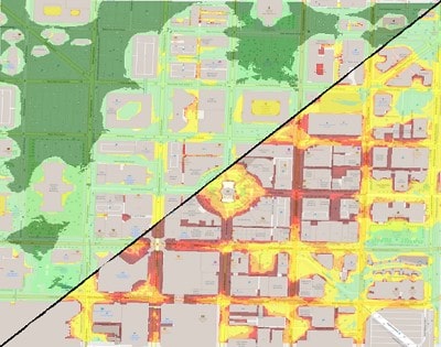
Spirent GNSS Foresight uses advanced 3D modeling and ray-tracing to predict and map areas where GNSS signals are likely to be degraded, and at which times of day. Drone operators can use Foresight before and during a flight to identify, anticipate and avoid areas of known GPS degradation.
Foresight is available as two separate solutions, depending on the requirement. Foresight Live calculates GNSS for every meter, every second, from 1-100 meters above ground level, for the current time and days/hours in the future. In doing so it enables planning and real-time decision-making to ensure GNSS continuity and reliability. Foresight Risk Analysis, meanwhile, provides best-case, worst-case, and 90th percentile predictions over a given service area to determine where GPS can always be assured.
From GNSS chipsets to whole UAS, Spirent hardware and software solutions can test the equipment’s ability to navigate in areas of GPS degradation. Drone operators can combine this knowledge with data from Spirent GNSS Foresight to make intelligent decisions about where and when the drone can safely fly BVLOS.
For more on how Spirent is helping to enable safe autonomous drone flight beyond visual line of sight, see our ebook Achieving Reliable GNSS Performance for Autonomous UAS Navigation.